It is produced by the air circulation opposite to the direction of the hemisphere in which it is located. This produces changes in temperature and in the climate where it manifests itself, generating dry, sunny or very cold climates with clear skies.
Its name is given because it goes in the opposite direction to cyclones or squalls.
History
It has a cyclical history since this phenomenon is repeated irregularly every year as pressure changes and air mass movement effect.
Climatic changes and environmental deterioration have generated effects on the anticyclone behavior, sometimes extending its duration and intensity.
How does the anticyclone originate?
It originates with high atmospheric pressure. The air descends on the ground from the upper layers of the atmosphere generating a phenomenon called subsidence.
The development of an anticyclonic type of air circulation is called anticyclogenesis and, depending on how it is, anticyclones are classified as warm or cold.
Effects
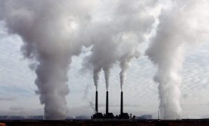
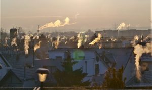
Anticyclones generate some meteorological effects in the areas where they occur, such as fog, frost, increased pollution, clear skies and even headaches. All these effects occur in the northern and southern hemispheres of the planet, altering the temperature and the movement of air masses in both spaces.
Representation
The anticyclones are represented in maps with lines that join the points of equal pressure called isobars.
The isobar maps show the graphical representation of the anticyclone’s behavior over the spaces covered by this phenomenon.
Examples of anticyclone
In different parts of the world, there have been many types of anticyclones with very specific characteristics.
Several types of anticyclones are presented below.
Siberian anticyclone
This meteorological phenomenon occurs in Eurasia during most of the year and is characterized by a mass of dry and cold air with temperatures that can reach -60 ° C. It is the strongest in the northern hemisphere and is responsible for severe winter cold and dry conditions in Siberia.
The start time of this is given in August, takes hold in December and continues until the end of April.
Subtropical
In the subtropical zone, large, elongated anticyclones are generated, which tend to stand out in the average distribution of pressures in any month. These anticyclones are stationary or move very slowly.
There are two anticyclones in the subtropical zone. These are the Azores and the Pacific.
Dynamic
The dynamic anticyclone originates with the decrease of an air mass that is pushed to the surface of the Earth by advection in the elevated zone. In this type of anticyclone the climate is hot, dry and sunny.
North Atlantic anticyclone
The North Atlantic anticyclone also known as the Azores anticyclone; it is a dynamic anticyclone situated on the Portuguese islands of the Azores. This phenomenon presents a dry, sunny and hot climate in the summer seasons and can extend its influence in autumn, spring and even winter. The center of it, is usually located in the middle of the Cantabrian Sea, causing dry winters and displacing existing cyclones.
South Pacific anticyclone
This anticyclone is the product of high pressure, the circulation of air masses from south to north that collect existing moisture, transporting it to the coasts where they condense generating low clouds in the months of May to October with high moisture content in the atmosphere.